
Mapy
English title: Maps
Polish subtitle: Obrazkowa podróż po lądach, morzach i kulturach świata
Publisher: Wydawnictwo Dwie Siostry
Warsaw 2012
Dimensions: 27.2 × 37 cm
Hardcover: 110 p.
ISBN: 978-83-65341-04-4
This book started the Maps Series.
If not stated otherwise photos below are taken from the third Polish edition.
In Poland this book is also available as an extended Purple Edition. You can also buy a green expansion to the original (blue) book that contains maps that were added in the orange and purple edition.
You can see what country is in which edition in this Google Sheet.

“Mapy” were published in over 30 countries (see details below) in a total circulation of over 3 million copies and it’s our biggest bestseller yet. They won, among others, Prix Sorcières and Premio Andersen, the most prestigious awards in the field of children's literature awarded in France and Italy.
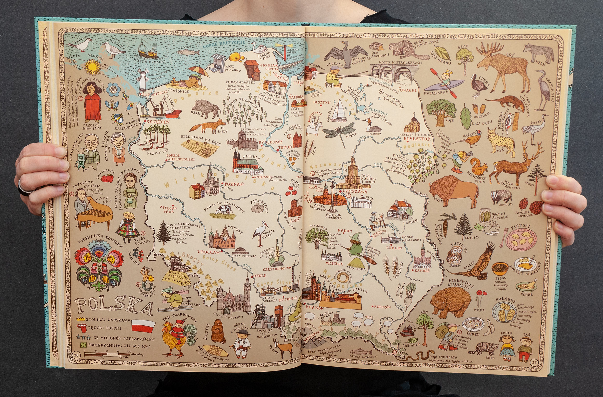
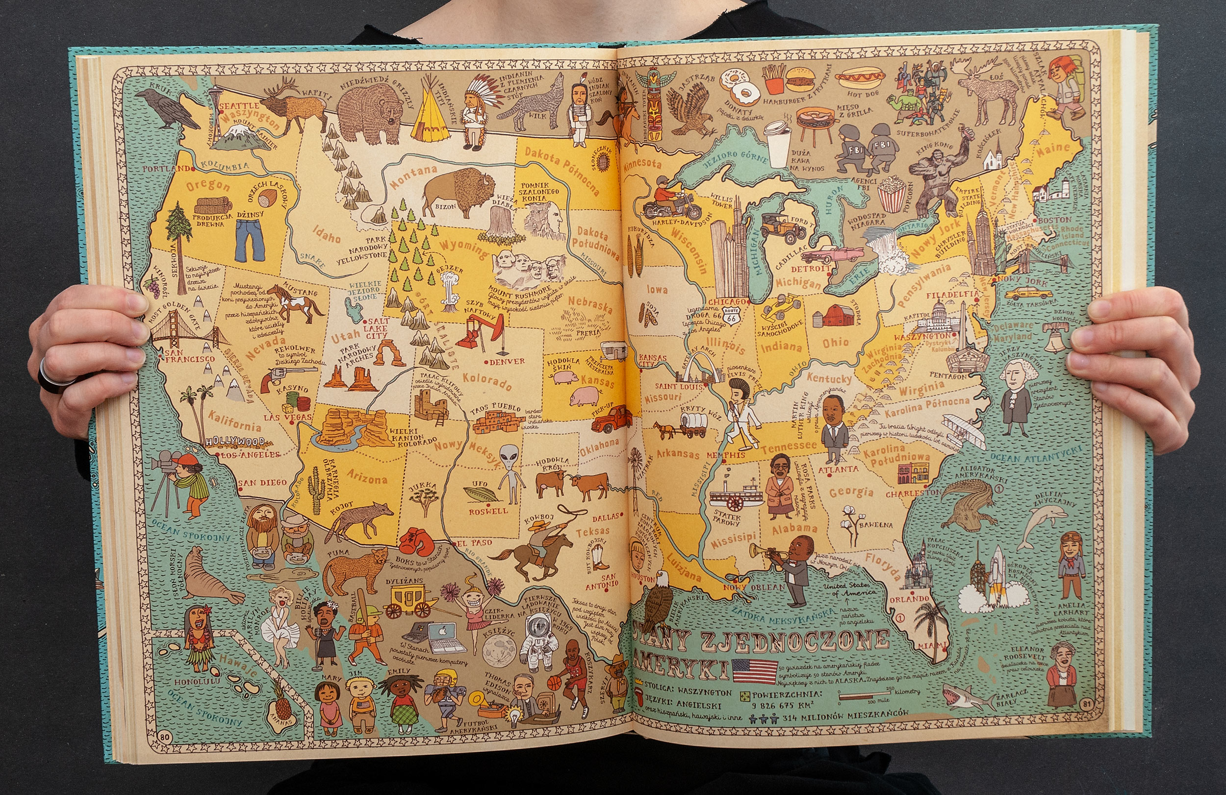
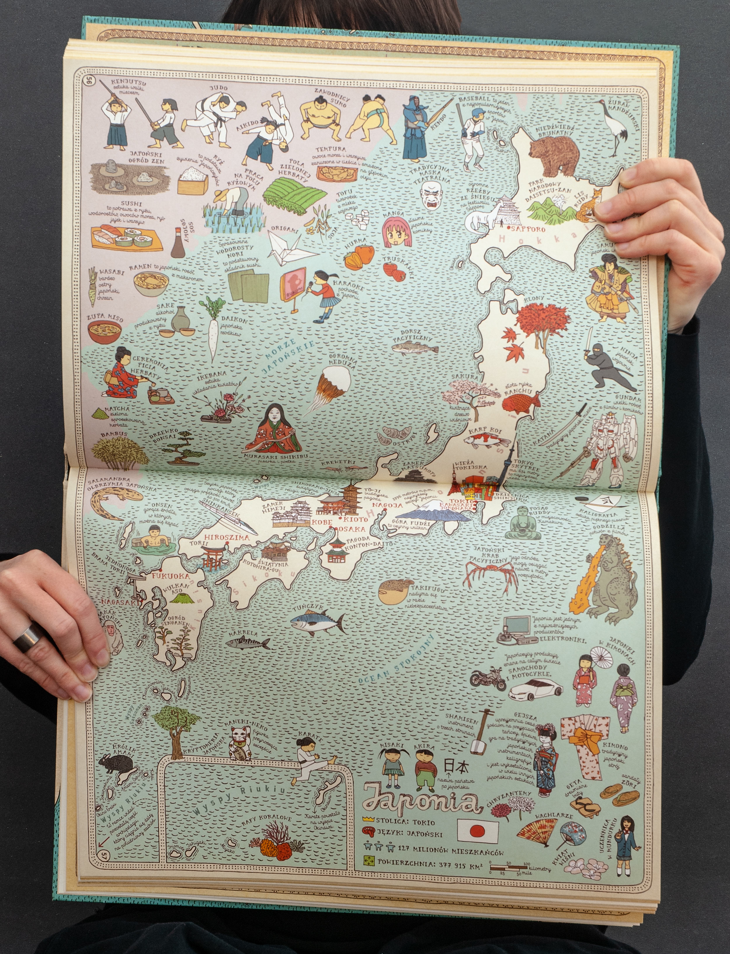
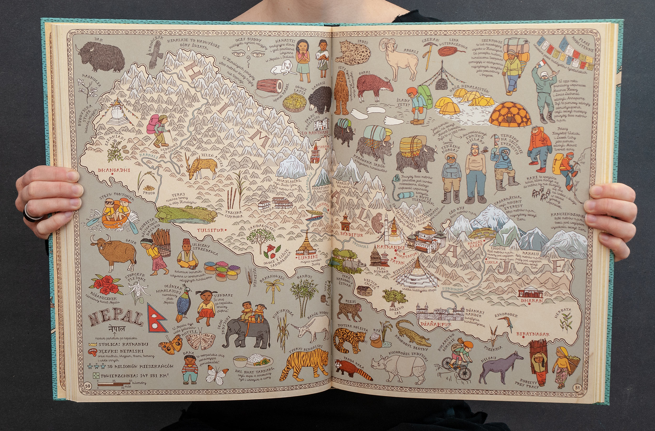
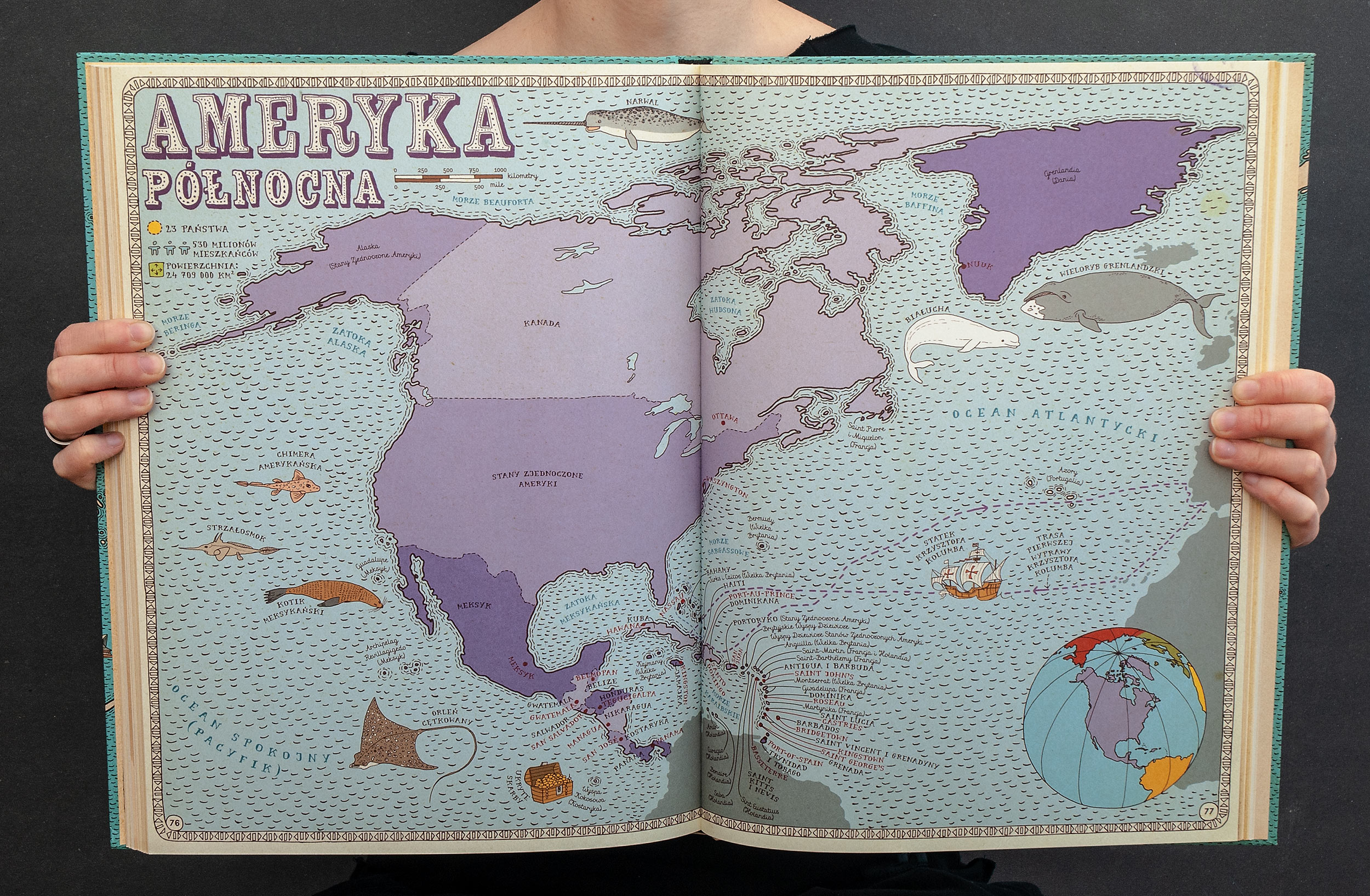
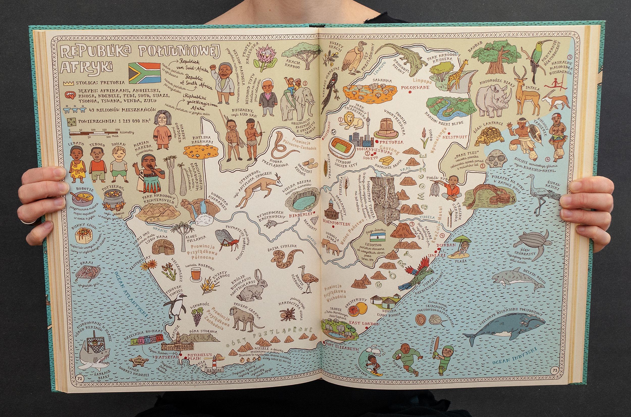
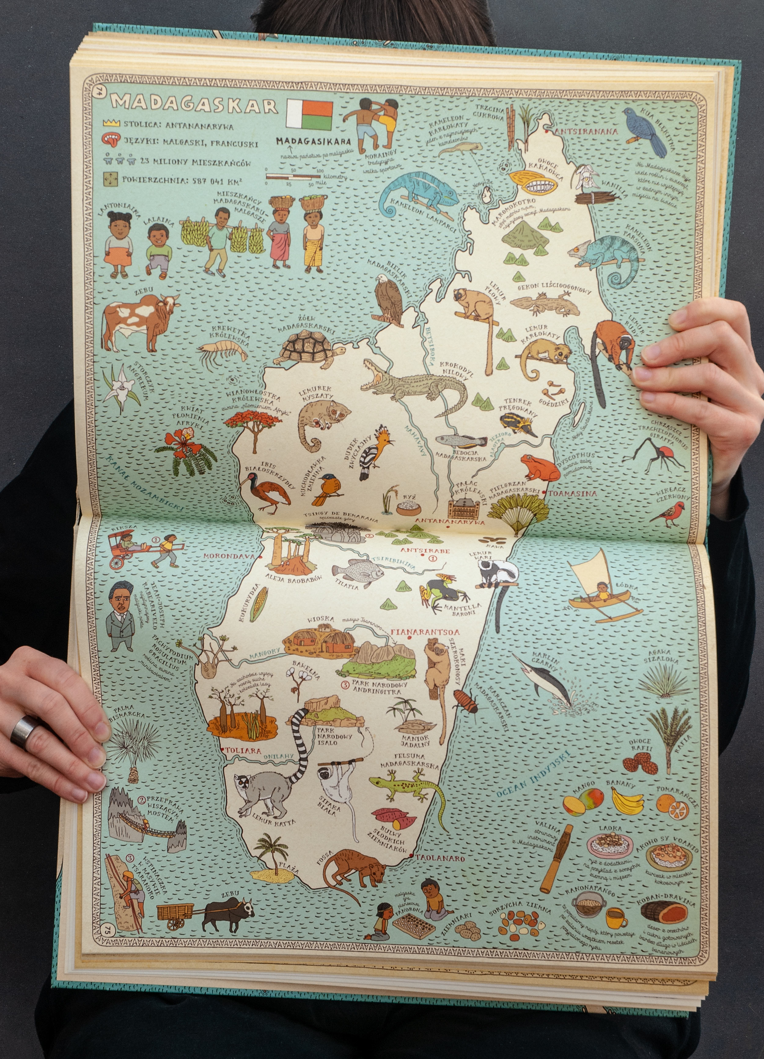
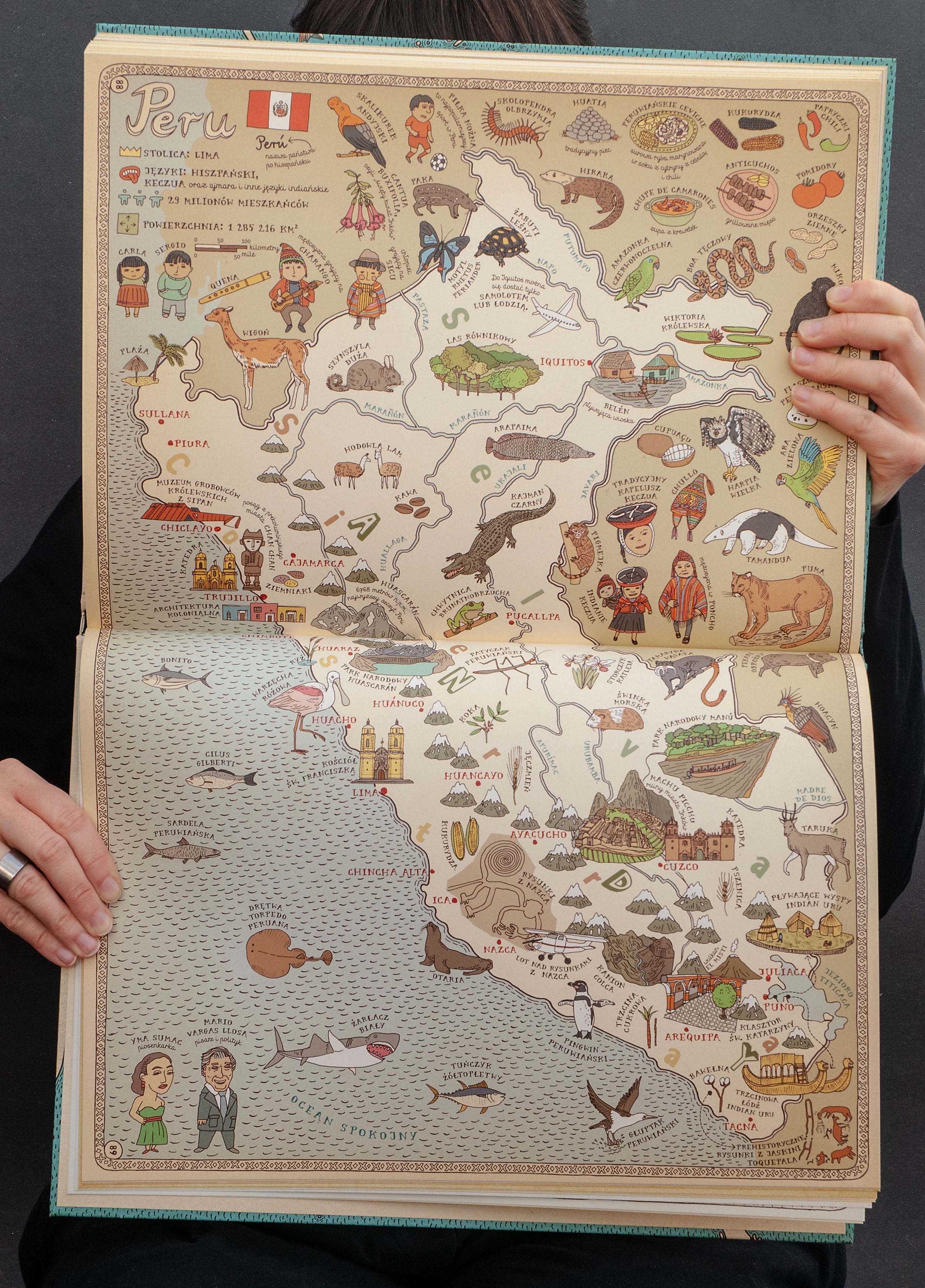
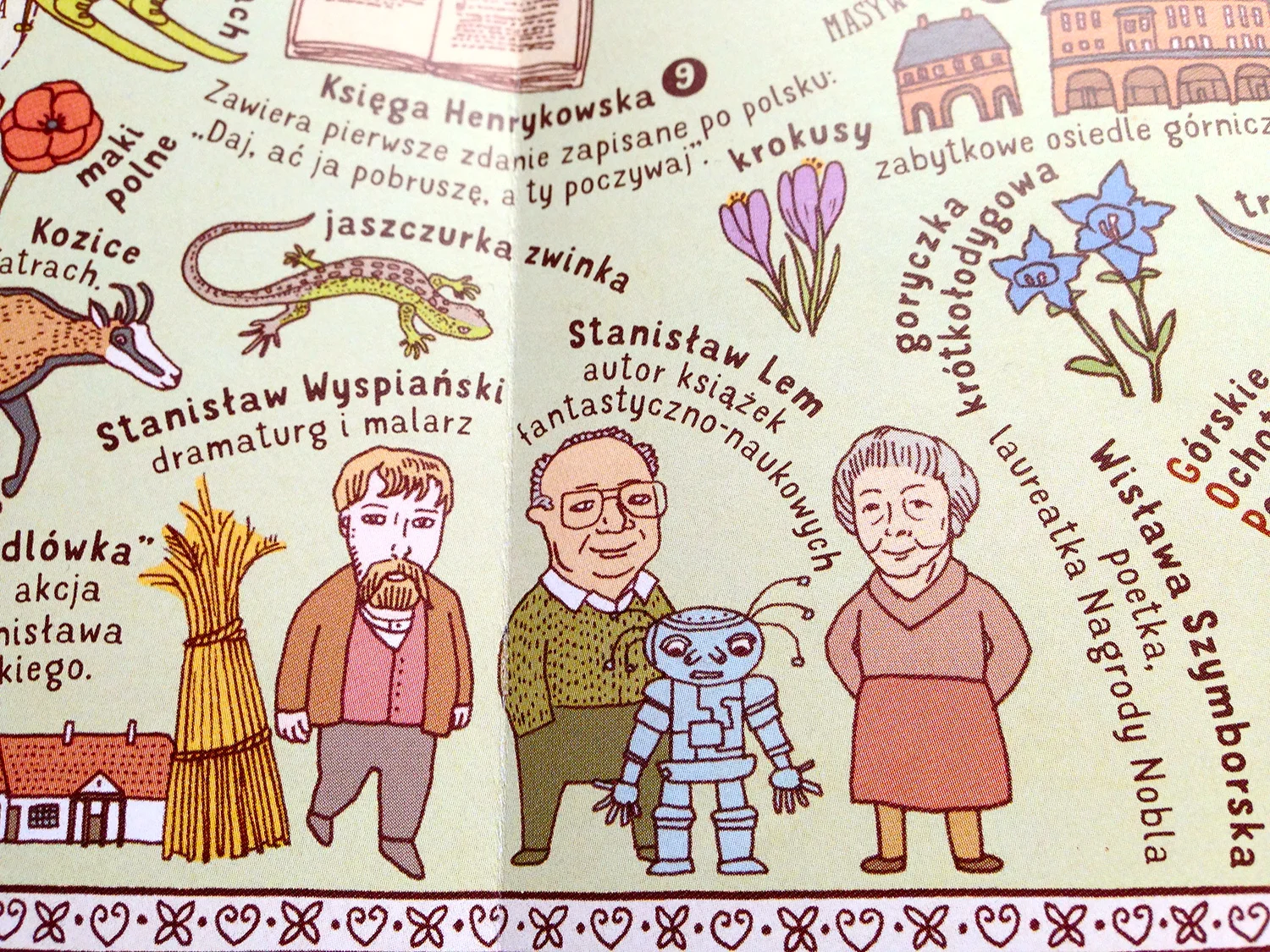
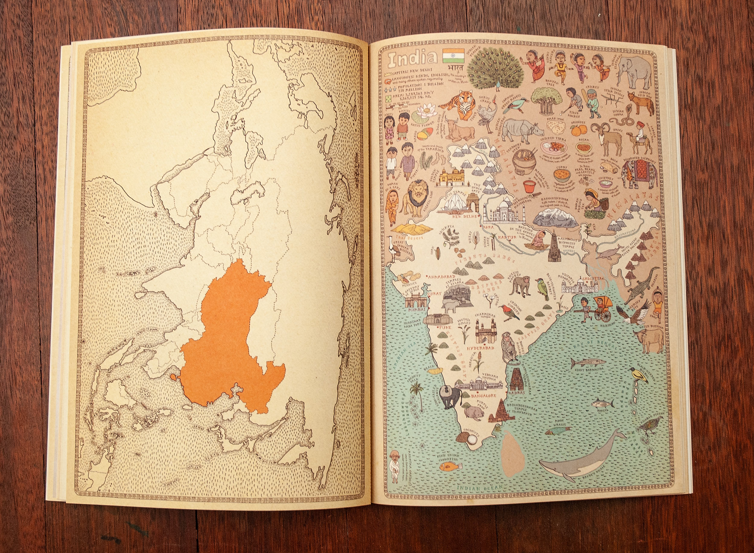
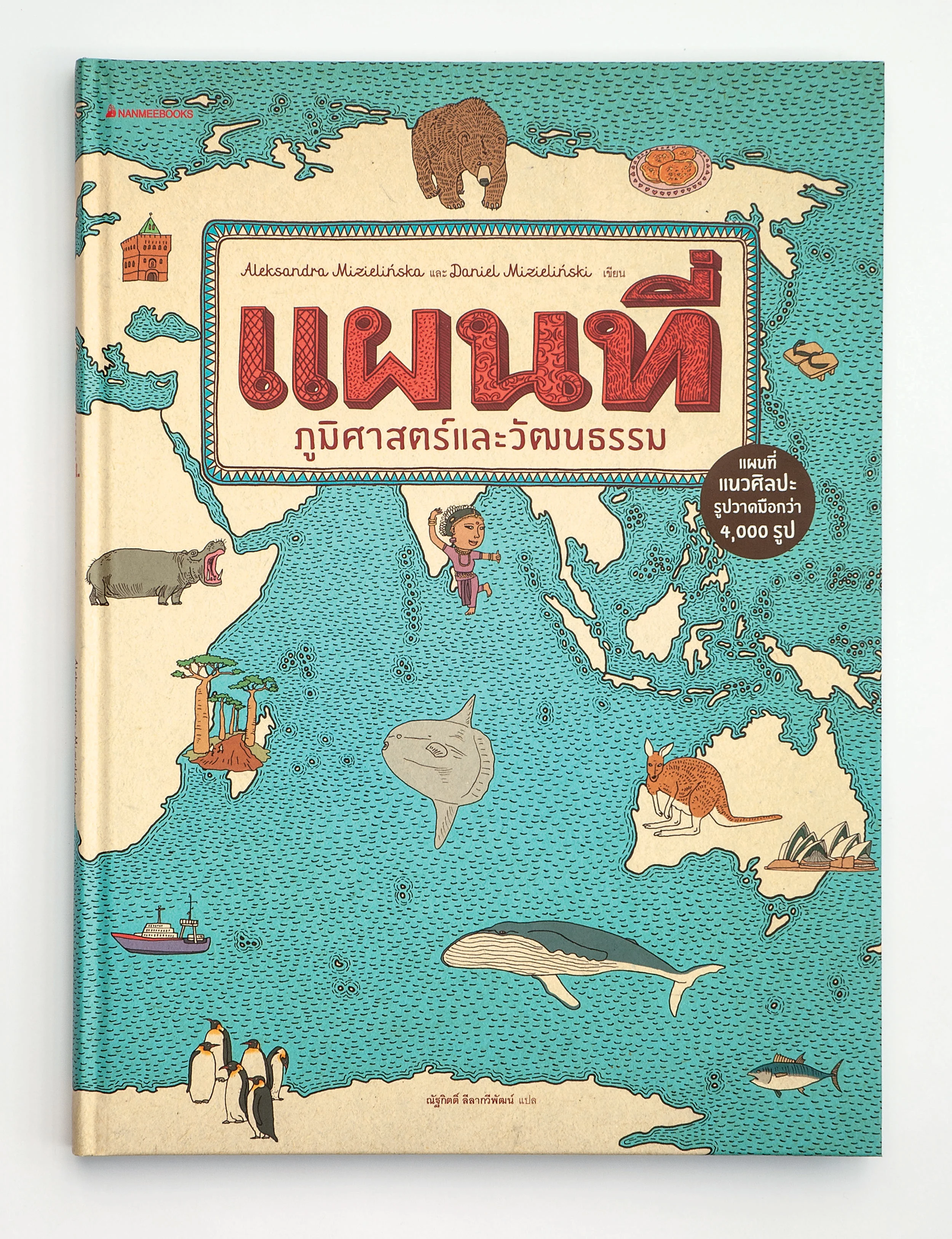
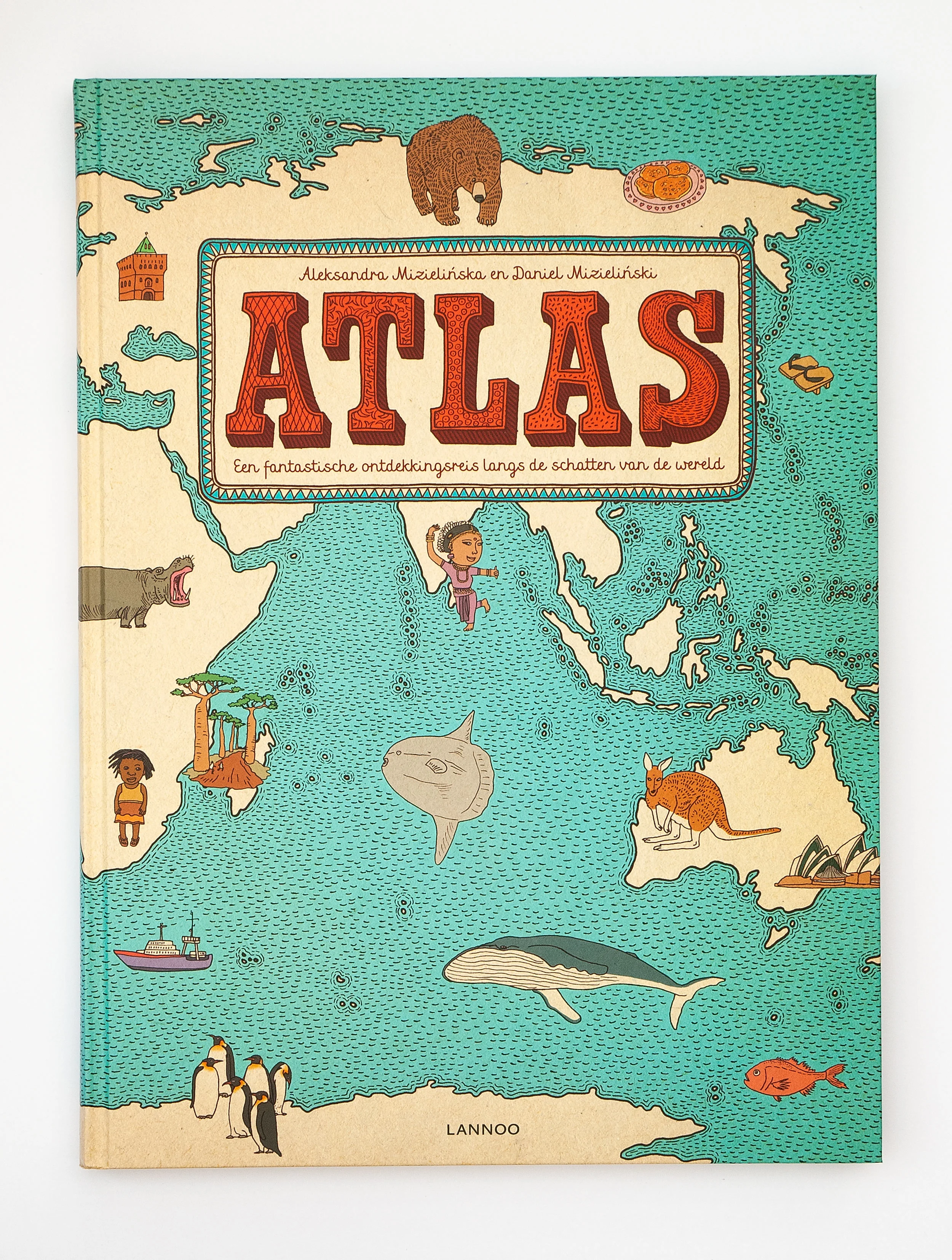
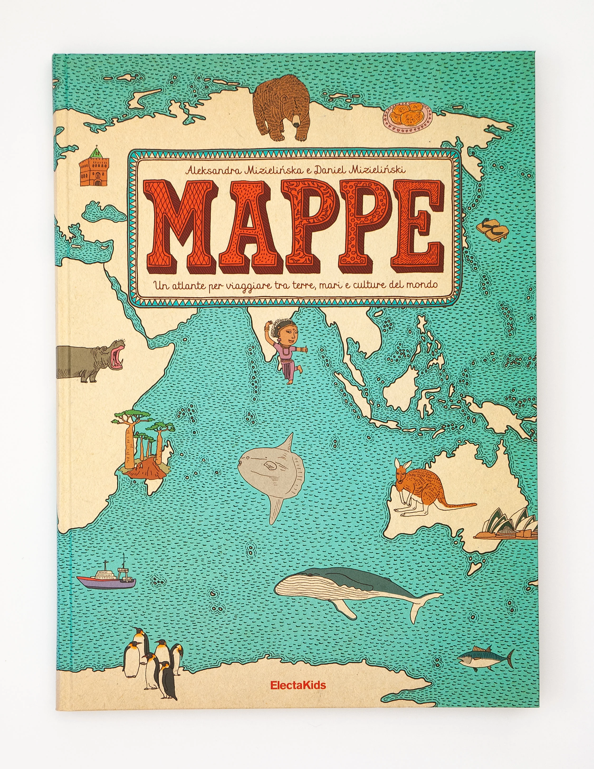
The first edition (also known as the “Blue Edition”) contains 51 richly illustrated, full-sized maps presenting 6 continents and 42 selected countries*. Each map contains 90–120 detailed illustrations which represent animals, plants, famous people, monuments, popular dishes and interesting facts from the fields of culture, art, and science.
It took us 3 years to create this book. We drew the first map in 2009. We started with Poland, then we took on USA and Japan. Those three maps were our test field. When you look closely, you can even see how differently some animals are drawn on the map of Poland. After that we decided that this book is going to work, but we haven’t shown it to anybody until we had more then 20 maps finished. With that we went to our publisher (Wydawnictwo Dwie Siostry) and asked them whether they were interested in publishing the book. They were, and here we have to acknowledge a simple fact: without them this book would probably end at 5000 copies and wouldn’t be available outside Poland. Dwie Siostry is truly the best thing that happened in our carrier. We worked with other publishers, so we are fully aware that we wouldn’t succeed with somebody else.
*Countries depicted in original, Polish, Blue Edition (in alphabetical order): Australia, Austria, Belgium, Brazil, Canada, Chile, China, Croatia, Czech Republic, Ecuador, Egypt, Fiji, Finland, France, Germany, Ghana, Greece, Iceland, India, Italy, Japan, Jordan, Madagascar, Morocco, Mexico, Mongolia, Namibia, Nepal, Netherlands, New Zealand, Peru, Poland, Republic of South Africa, Romania, Russia, Spain, Sweden, Switzerland, Tanzania, Thailand, United Kingdom, United States of America.
Why maps?
Some journalists and bloggers seek for origins of some of our books. For example, once we read that we supposedly created “Who eats whom” after we saw a wagtail eating a ladybird. Well… no. I don’t think if I’ve ever seen a wagtail.
As for “Mapy”, there is no single event or an anecdote that pushed us to this project, too. But there are a few undeniable facts. We love old maps, we love old encyclopedia, and the colourful inserts that are scattered inside them, we love accumulating tiny drawings, and we love to learn new things about the world.
Also, if you need to have a legacy story, we can mention that Ola’s mother spent most of her career drawing maps. But we’re not sure if it had any influence on our work or inspirations.
Long road
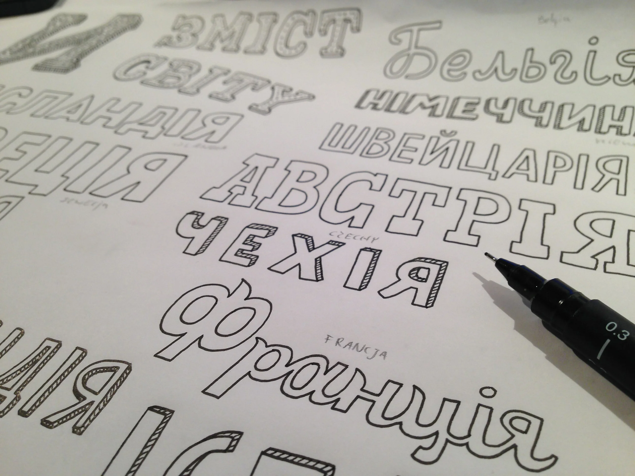
Aside of creating over 4000 illustrations we had to design two typefaces just for this book (Mrs White and Cartographer). Hand lettering every single little side note was not an option. Not just because it would significantly complicate the editing process, but mostly because of foreign editions. It would be crazy to hand draw each one of 4000 descriptions for every edition, so we kept only hand written maps titles. Creating fonts consumed 6 months*.
We needed 2 weeks for one map. After finishing it, we worked for 3 months with our brilliant editor, Maciej Byliniak, to check every fact in the book and make sure to avoid any mistakes. In first run we had some minor ones, but they were corrected on the next print.
Our work didn’t end with sending files to the printing house. After that, we started working on foreign editions. This involved hand drawing headlines to every map, checking typesetting (this book is extremely hard to typeset correctly, just take a look at our typesetting instruction) and creating new maps for publishers from countries that were not included in the original edition. At first it was tiresome and we wanted to have more time for new projects. Fortunately we appreciated the opportunity of constantly improving “Mapy” and reaching such a huge audience.
* We also used our font Bubol that was created for our game/chat Bubole and Saturator FA designed by Polish type foundry Fontarte. In some foreign edition Saturator did not cover all of the diacritic characters and it was substituted by our Mr Dodo.


Photo from 2012 edition on the left, 2016 edition on the right.
Third edition
In 2016 we decided that we’re not happy with some details of the book and we want to change them. We already had a second edition removing some obvious mistakes but after receiving feedback from readers we saw some issues that we weren’t aware of.
For example, on every map you can find famous person (or two). We decided that we’re going to show influential people whose work had big impact, not only domestically, but globally. Ow, and they had to be dead. That was a mistake and created a big problem with representation. I don’t know why we thought it would be a good idea to include this category in the book (like selecting just two people wouldn’t set any controversies whatsoever), but we couldn’t take that back so we had to fix it.
In total we added or updated over 200 drawings, changed some of the texts and moved things around. This would be a simple task if we didn’t have any foreign editions to think of. But we wanted to apply those updates globally. It took us another 3 years to do that. It’s not easy to convince other publishers to redo a finished book that they published just one or two years ago.
You can’t do that
“Mapy” have changed nonfiction picture book market. Even our precisely chosen book dimensions that were initially rejected by most foreign publishers (some tried to force us to shrink the book to A4 size, but our Polish publisher stood by our side) now are one of the widely recognized standards. Currently, almost every children's book publisher has at least one book in the 27.2 × 37 cm format in their offer. Even shelves in bookstores were redesigned to accommodate this format. The term “oversized picture books” that was used loosely for big books, today applies to these specific dimensions.
More than “Mapy”
In 2014 we made one other “Mapy” related project. We were contacted by Leon Food restaurants chain owners. They were opening a new branch at the Terminal 2 of the London Heathrow airport and they needed a huge (630 × 305 cm) World map for one off the walls. It was supposed to be there just for one year but I think they like it, because in 2018 it was still there.
One year after the publication of the Blue Edition we expanded the world of “Mapy” with “Mapownik” (an activity book). In 2017 we started working on map-themed jigsaw puzzles. After a few weeks of research and testing dozens of jigsaw puzzles from different manufacturers and publishers we created “Animals on the Map” and “Everything on the Map” which were published at the end of 2018.


Maps for Polish government
The success and recognizability of “Mapy” attracted more and more different private and public entities. They wanted to get some of that spotlight for themselves. After creating the map for Leon we rejected almost all similar inquires. The only one we agreed to was a commission from the cabinet of Polish Prime Minister Donald Tusk to create a map of Poland for the celebration of 25 years of Polish independence. We were hesitant about working for Polish government, but together with our publisher we decided that something good can be done here. Well… we weren’t exactly wrong about that but we didn’t realize how thick low level officials can be.
It was 2014 and about that time the government issued their first free textbook that was created for primary school first grade students. That book was hideous and stirred a vivid discussion among Polish book writers, illustrators, educators, academics and designers. We thought that maybe instead of just grumbling about it we could show how government projects for kids could be done.
Eventually, after some really disheartening talks with a lot of sad people, the project was finished. We skipped about 90% of content they wanted to shove down our throats and the illustrations and layout were accepted basically without any changes. In the end it was a 65,8 ×47 cm folded, two-sided poster. It was distributed for free by Polish Postal Service to any child that wanted it (you could sign up to get a copy on a dedicated website).
Together with Dwie Siostry we were also responsible for the production side of the project. This guaranteed that nothing would be changed without our knowledge. Well… somehow they managed to add to every map an additional piece of paper with some dumb text on it. We found out about it after the fact.


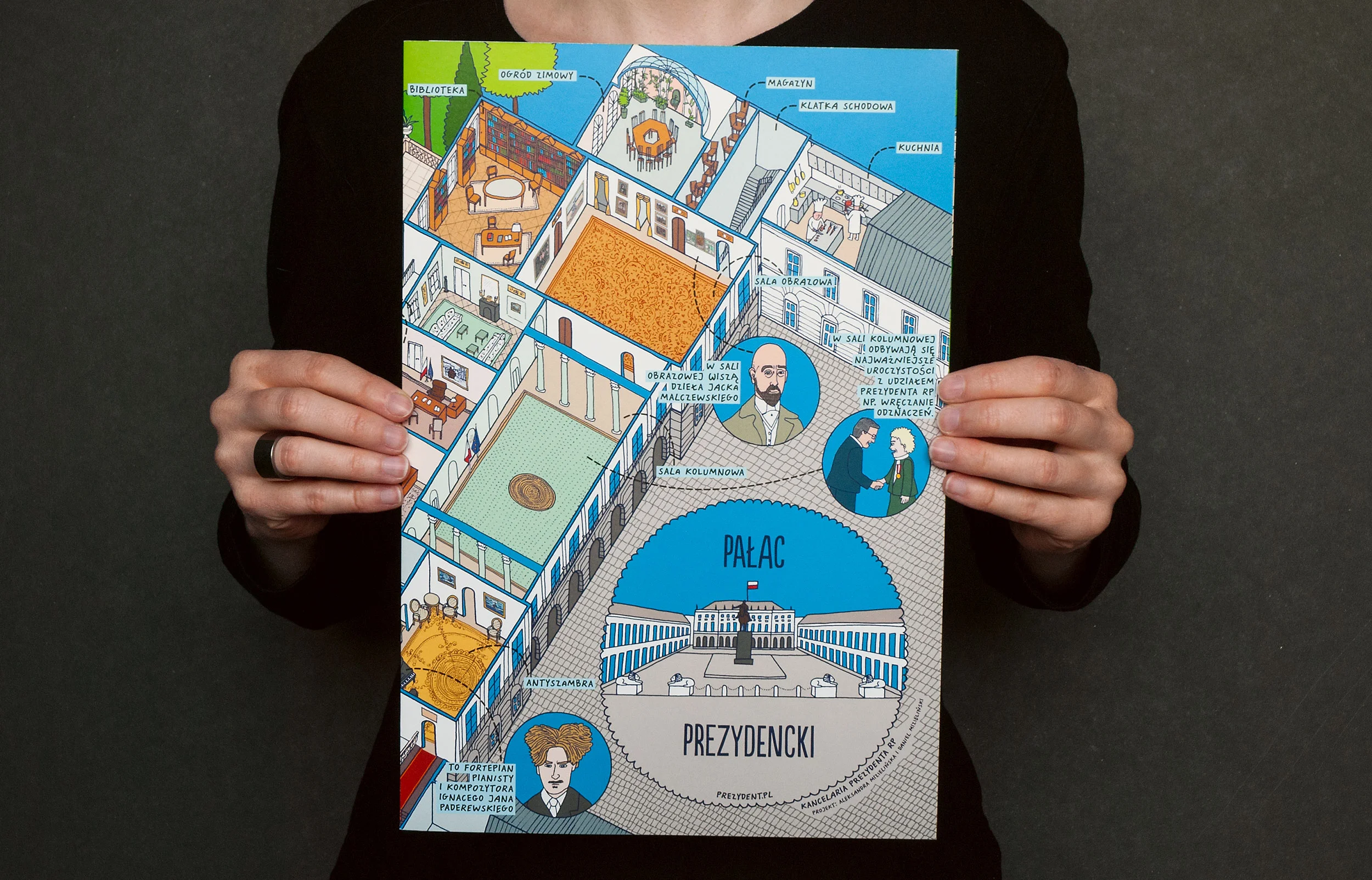
Presidential maps
Another map-like project was commissioned to us by the cabinet of the President of Poland Bronisław Komorowski, also in 2014. We were asked to create maps of two buildings:
Presidential Palace – the official seat of the President of the Republic of Poland.
Belweder Palace – the much smaller palace that was used as an official residence by Polish presidents.
This time the collaboration was smooth and nice. Mrs. Rita Stokłosa was a presidential stuff member and working with her was a breeze. In the end we created three maps. One of them had a removable characters that allowed children to recreate a visit of foreign head of state. The design was very different from the one in the “Mapy” book, but without the book this project would probably never come to be.
The maps were given to kids visiting either of the palaces during school field trips.


Other stuff
During first years after “Mapy” were launched, there were also a few gadgets produced by foreign publishers with our consent, but without excitement. We had a “Maps Poster Book” with tear-off pages (Great Britain, US, and Taiwan), blankets and wall calendars (from 2015 to 2019) in Germany and a totally senseless layered wall calendar in Japan. We didn’t want to manufacture too many side products, because a lot of them felt like a shortcut for earning more and not a solid approach for delivering value.


In 2016 Dwie Siostry Publishing House was celebrating its tenth birthday. On that occasion we (authors and publishers) decided to distribute a new version of “Mapy”. We already had maps that were created for foreign editions and were never published in Poland. 16 additional countries were added making it 58 total. In Poland “Orange Edition” had a limited run of 25 000 copies and it won’t be reprinted. In other countries it functions as a regular, non-limited, expanded version. You can read more about it here.
In 2019, after “Orange Edition” was long gone, we prepared even more extended Purple Edition with a total of 66 countries and a Green Edition that is basically an expansion to the original Blue Edition.
How “Mapy” are made
1. Research
For each map we start with an extended research. We have a template in google documents that lists all of the categories that are represented on each country’s map. We fill this template with 200–300 elements. Each contains a picture, description and source of stuff that can be interesting for kids, attractively represented on the map, and is found compelling by us.
Some of the data can be collected from our usual sources. For example, population and total area can be found on the CIA website, geographic range of animals is available on the Red List. It’s also easy to get a list of biggest cities, rivers, lakes, and mountains. Finding agricultural (what and were is cultivated) and economic (what goods are exported) facts is also usually not a problem. Sports, art, traditions, non-material heritage and popular activities are a little bit more tricky, but famous people are definitely the hardest to select.
While working on the book we have also found that personal blogs written by people who travelled or live in the country we were interested in provide a very useful, first-hand facts.
Aside of general knowledge we have a rule to show things that native people are proud of.
2. The map
After the research we start with the background picture. We download and print a real map and trace it on the layout paper that has exactly the same dimensions as a spread in the book, add waves on seas and oceans, frame the drawing with a unique pattern, and put everything on a scan of old paper (different for each map).


3. Thousands of little drawings
When the background is ready we start drawing things listed in the research. We start with things that are specific for the particular location. Then we add things that are typical for the whole country (those will be placed outside of the country’s borders).
When we have at least 50 pictures, we arrange them on the map in Photoshop and add descriptions in InDesign. This way we can see how much space is left and where next elements need to be added (which is important if there is a free space inside the country borders). Finally, we add colours. Every drawing is a separate Photoshop group with a set of solid colour layers. This way it’s easy to make changes and during the editing process there’re going to be a lot of big and tiny adjustments.


Wars, nationalism, and censorship
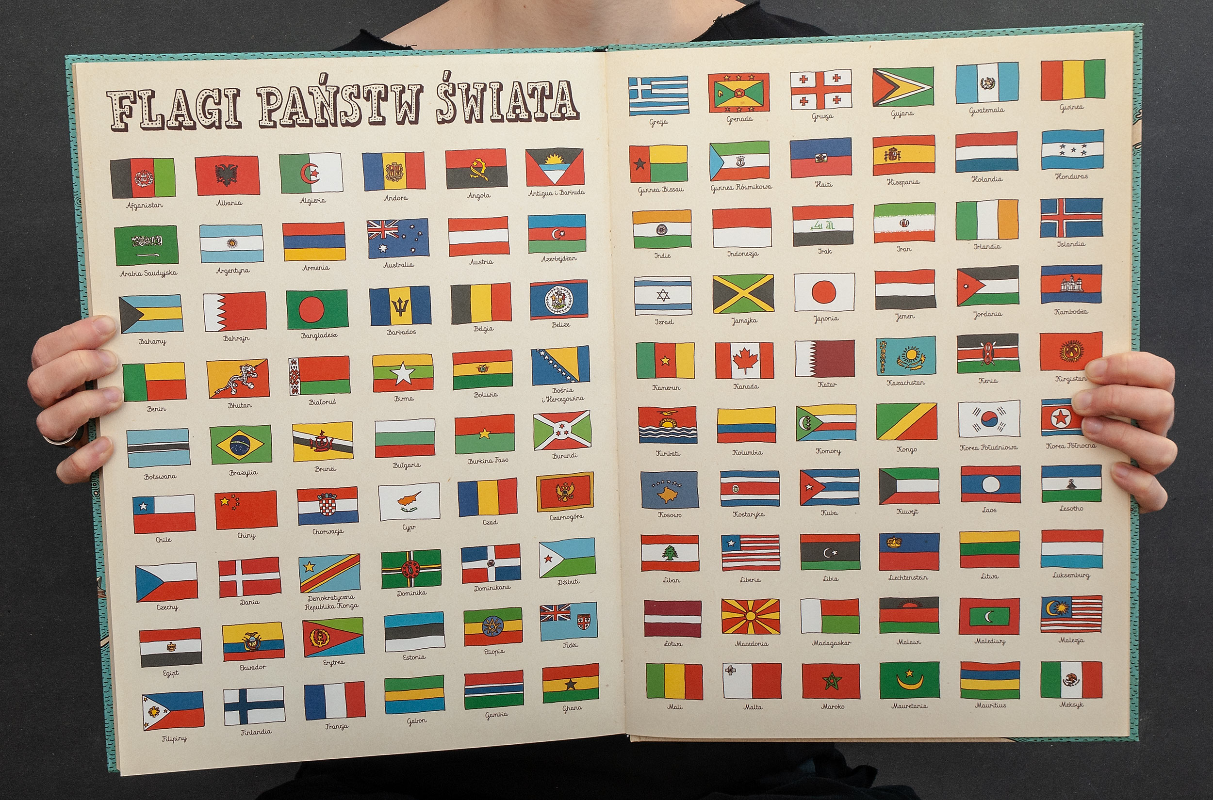
When we started working on this book we didn’t spend a single second to think about repercussions of making such highly political book. If we did this, the book could never see the light of a day. Think about it. We not only had to select a group of countries to show (showing all 195 countries in one book of this size is technically impossible) but we had to decide on where the borders should go.
Since the first foreign edition we’ve had many minor and major problems surrounding this subject so generally we decided on two main rules:
Use a Google Maps rule for borders: the borders are adjusted to match the borders that are officially recognized by the state were the book is published.
Never removing land but covering controversial parts with images is a viable solution.
Let me give just a few more distinct examples.
Taiwan
Only 18 countries recognize Taiwan as an independent state. Poland is having diplomatic relations with Taipei but as of today (April 2019) we don’t have an embassy, but only Polish Biuro in Taipei. So should we draw it as a separate state on the map of Asia? Should it get its own spread? Well… in the original and most foreign edition it is marked as an independent state. But in Chinese edition it’s a part of China. Also, for the extended edition we drew a map of Taiwan which was received with a lot of love from Taiwanese readers and was used by the Taiwanese publisher as a political statement during the promotional campaign.
China
Every map published in China has to go thorough rigorous censorship by National Administration of Surveying, Mapping and Geoinformation of China (NASG). It' sounds bad but in practice it’s just annoying. Some obvious corrections concerned changing borders between China and neighbouring countries, other requests required some images to be moved not to cover the Chinese border (the whole border had to be seen). In some places additional lines were added to show that some borders are undecided, or a strip of territory is under dispute, or that it’s a part of demilitarized zone.
Adding additional markings was senseless and inconsistent but in most cases rule number one was in use. Unfortunately, a few changes were just stupid. For example, NASG insisted on changing a red dot that marked the location of Beijing (and every other state capitol in the book) into red star. Why? We don’t know. Did we agree to change it? Yes because it’s a trivial thing to fight for and without this change the book wouldn’t be allowed on the Chinese market.
Turkey
This edition had the most peculiar problem. The issue was with Aegean Islands – a very sensitive political and diplomatic problem. It’s also extremely childish. Mentioned islands are in dispute between Greece and Turkey. Turkey can’t claim them without starting a war (in words of Wikipedia: “…since 1970s. It has twice led to crises coming close to the outbreak of military hostilities”) and no one accepts the responsibility of letting those islands go – that would be considered a high treason. So the authorities' solution is to ask for not including them in any printed materials.
Removing islands or any other land contradicts with our second rule. The Turkish publisher didn’t want to just cover those islands with an image of a fish or a bird, so this edition has been suspended since 2016. Finely at the beginning of 2019 our solution was approved and (hopefully) readers will enjoy this only slightly modified edition.
Portugal and Ireland
What those two European countries have in common? They both have a very patriotic citizens that will let you know if they have a problem. In the original Blue Edition those countries were not included. We got a lot of hate mail from Portugal about that. How many is a lot? Like 100 emails a day for two weeks. Someone noticed the book during a trip to Japan and posted it on Facebook.
The Irish were not that cruel. We received some angry but not vulgar emails about not including Ireland but the real rage came from the US in the form of comments on Amazon, Facebook and other platforms.
In both cases those countries were added in the extended edition.
Israel and Palestine
Some readers expect that we solve this long lasting brutal crisis and want us to include a map of Israel in the book. But how would any one approach such problem? How could we create an objective map of a state whose borders are not only agreed on by the international community but are in a state of constant fluidity?
We didn’t want to show Israel without showing Palestine and even that was consider to be controversial. We tried to avoid the subject for few years but under a very aggressive pressure protocolary from American readers we came up with a solution: let’s make a shared map that would include both Israel and Palestine on a single spread without showing the borders between them – just the borders surrounding them. Let’s concentrate on the amazing aspects of both cultures.
Well… this solution didn’t satisfy anybody and that map as of writing this (April 2019) was never published. In addition, the picture with three religious books placed next to Jerusalem, that are symbolizing the significance of this city to Judaism, Christianity and Islam, were unacceptable by most people we showed the map to. To be clear, we did not write any names on the spines of those books so no religion was above the other. I don’t know if we’re going to solve this problem.
Edit 1: In 2023 the Israel/Palestine map was published in the extended German edition.
Edit 2: At the end of 2024 Israel/Palestine map was also published in Italian edition.


Reception
The success of “Mapy” is still unbelievable for us and I think we don’t fully comprehend it. When we drew the first map we had published only one book, we had zero foreign editions, we were freshly out of collage, and we lived and worked in a cramped flat and no one outside a small circle of clients knew who we were. From “Mapy” we expected a solid sales numbers that maybe would reach 10 000 copies and one or two foreign editions. Thanks to amazing publishing house Dwie Siostry, this goal was greatly exceeded.
We had a wonderful and uplifting feedback from kids from around the world but there were four moments that made us realize that “Mapy” might break some walls for us.
First one was the London premier of British edition. This was our first public launch of a book and people actually came, which was surprising.
Second one was the trip to China and Taiwan in 2017. The scale and dedication of our hosts was overwhelming.
Third was a big surprise and a proof that our book crossed on the other side of the mirror. It was an adorable photo of Dwayne “The Rock” Johnson feeding his partner while she was nursing/feeding their baby girl. We didn’t notice one detail at first but good people had pointed it to us: in the background you can see English version of “Maps”. That was it. We made it.
The last one was a surprise from Japan. A friend send us a still from a 2018 Mamoru Hosoda movie Mirai no Mirai. I don’t know how she noticed it but in the back you can clearly see “Mapy”. Anime was always a very important part of our lives. As children we were constantly watching a VHS with My Neighbor Totoro, Akira, Ghost in the Shell and many others. This fascination never faded out so seeing our work to be a tiny part of this powerful tradition was amazing.
This particular episode had an even bigger twist in 2019 when we had a press tour in Japan. We discovered that our Japanese publishing house was in a very close relationship with Studio Ghibli. This was a very exiting news for us and we can only hope that next time will be able to visit Ghibli which would be a dream come true.
After that visit we drew a map of Tokyo with some personal memories on the bottom. It was featured in the Animage magazine in the following months. Considering that Daniel started his carrier by drawing Sailor Moon when we he was eleven years old this was a satisfying character arc.


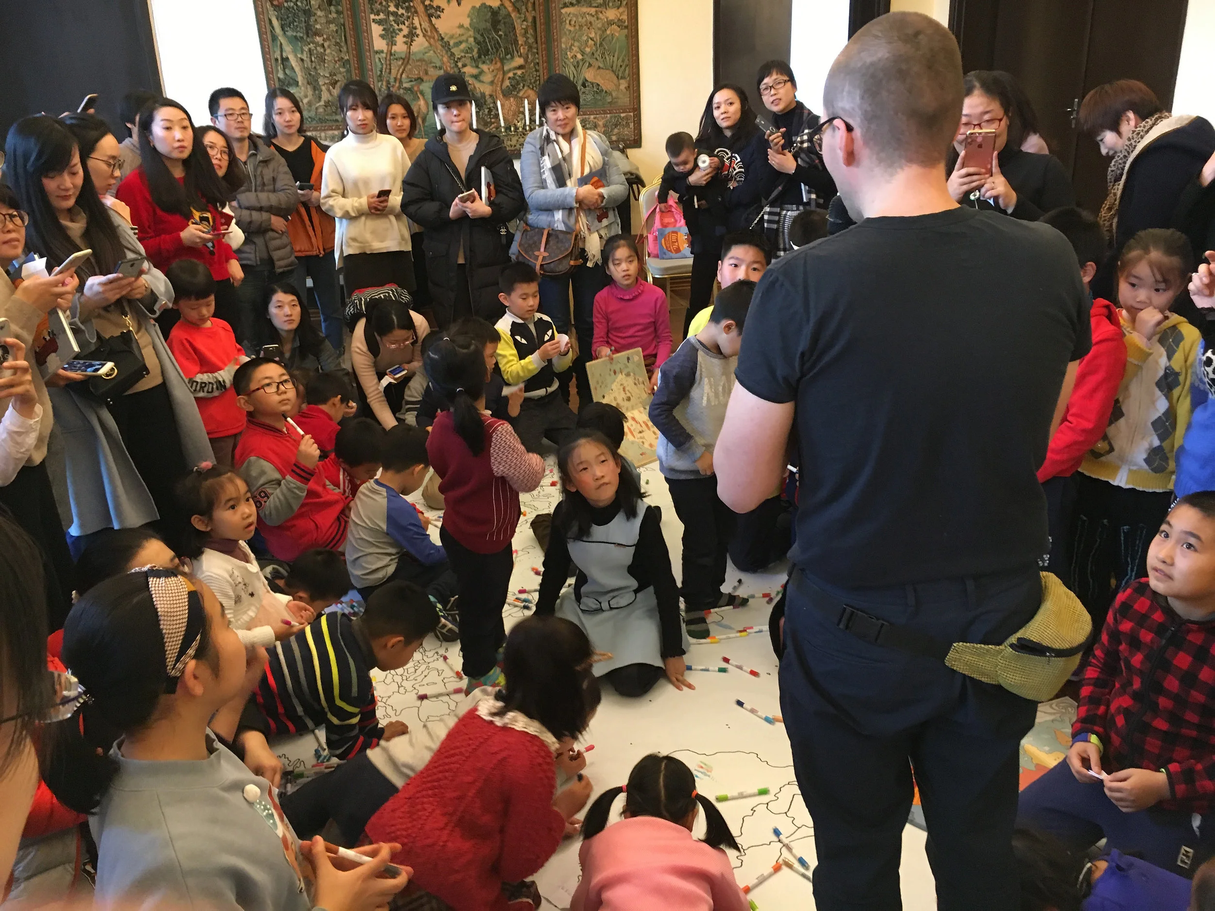


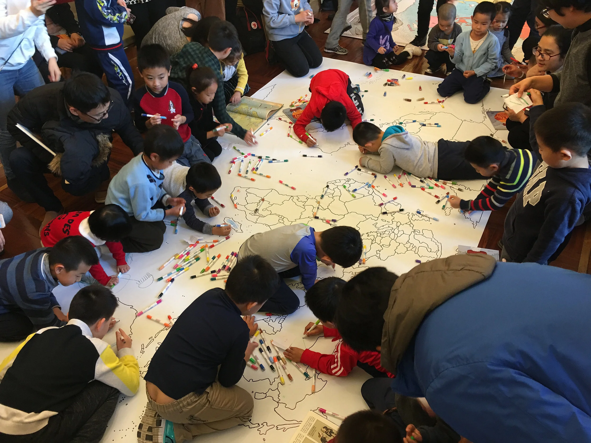
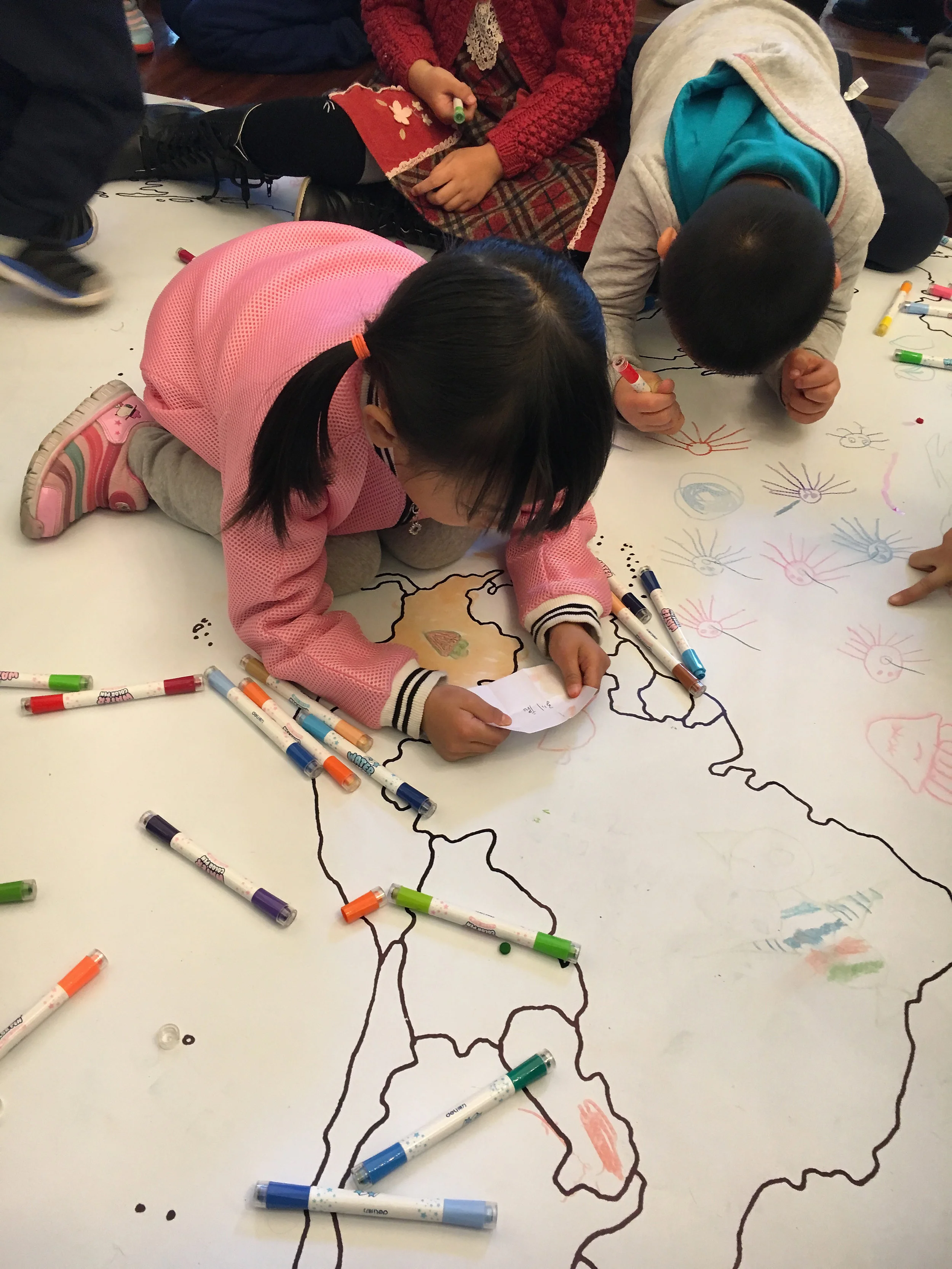
Workshops
We don’t do a lot of workshops with kids but we have at least one scenario for each book. With “Maps”, we try to engage kids in creating a huge map. We start with a print of a country’s borders on a paper that has at least 6-10 square meters and a bag filled with pieces of paper, each with a name of a thing to draw.


Copy/Paste
One amusing side effect of creating a popular book is seeing shabby copies of your work. The idea of a map with pictures is very old (duh!) and anyone can do a good job at it. It’s just that some authors think there is only one way to do it. Using those colors, and this scale, and even this particular frame pattern.
During few last years we’ve gathered a few examples but the one below is exceptional. A hint: the one on the left is not our book.


Selected awards
North Somerset Teachers’ Book Award 2015, Great Britain, given by Federation of Children's Book Groups
Nomination to The Kate Greenaway Medal 2014, Great Britain, given by Chartered Institute of Library and Information Professionals (CILIP)
Prix Sorcières 2013 in “non-fiction” category, France, given by The French Association of Librarians
Premio Andersen 2013 in “non-fiction” category, Italy, given by Premio Andersen magazine and Libreria dei ragazzi di Milano
Luchs – Dezember 2013, Germany, given by „Die Zeit” and Radio Bremen
Nomination to Waterstones Book of the Year 2013, Great Britain, given by Waterstones
Must Have 2013, Poland, given by Łódź Design Festival
Polish Section of IBBY Book of the Year 2012, Poland
Children Jury of Polish Section of IBBY Dong 2012, Poland
Magellan Award: Best Travel Publications 2012, Poland, given by “Literary Book Magazine”
Honorable Mention Most Beautiful Book of the year 2012, Poland, given by Polish Society of Book Publishers
A few words about foreign editions
At the end of this section you can find a summary of foreign Blue Editions. This part is not just a technical listing. Our books are very difficult to adapt – often the pictures are so tightly interlaced with words that even a small change in the volume of the text or change of the writing system require a layout redesign, typographic adjustments, or at very least, new lettering. This is very true in case of “Mapy”. We call it a visual translation and its function is to maintain the visual character of the project and to preserve the quality of the original edition.


This approach forced us to learn typography rules in non-latin scripts. We created lettering for Cyrillic, Georgian, Indonesian, Thai, Korean, Chinese (both simplified and traditional) and Japanese editions. We always consult our work with local designers to avoid mistakes and to achieve the best results. Even if we don’t typeset the whole book, we approve every single page of every foreign edition of our books. This is never just a technical task, but rather a creative puzzle.


The number of foreign editions and the time invested in them undoubtedly influenced our creative process and way of thinking about new book projects.
Foreign editions
Bulgarian, Карти, Benitorial, 2025, ISBN: 978-619-7639-37-7
Mongolian, Дэлхийн атлас, Жангар, 2021, ISBN: 978-99973-1-925-8
Serbian, Карте, Козикас издаваштво, 2020, ISBN: 978-86-6028-012-3
Greek, Χάρτες, Patakis, 2020, ISBN: 978-960-16-8428-4
Vietnamese, Bản dồ, Nhã Nam, 2020, ISBN: 978-604-77-3574-7
Croatian, Karte, Koncept Izdavaštvo, 2019, ISBN: 978-953-48552-5-6
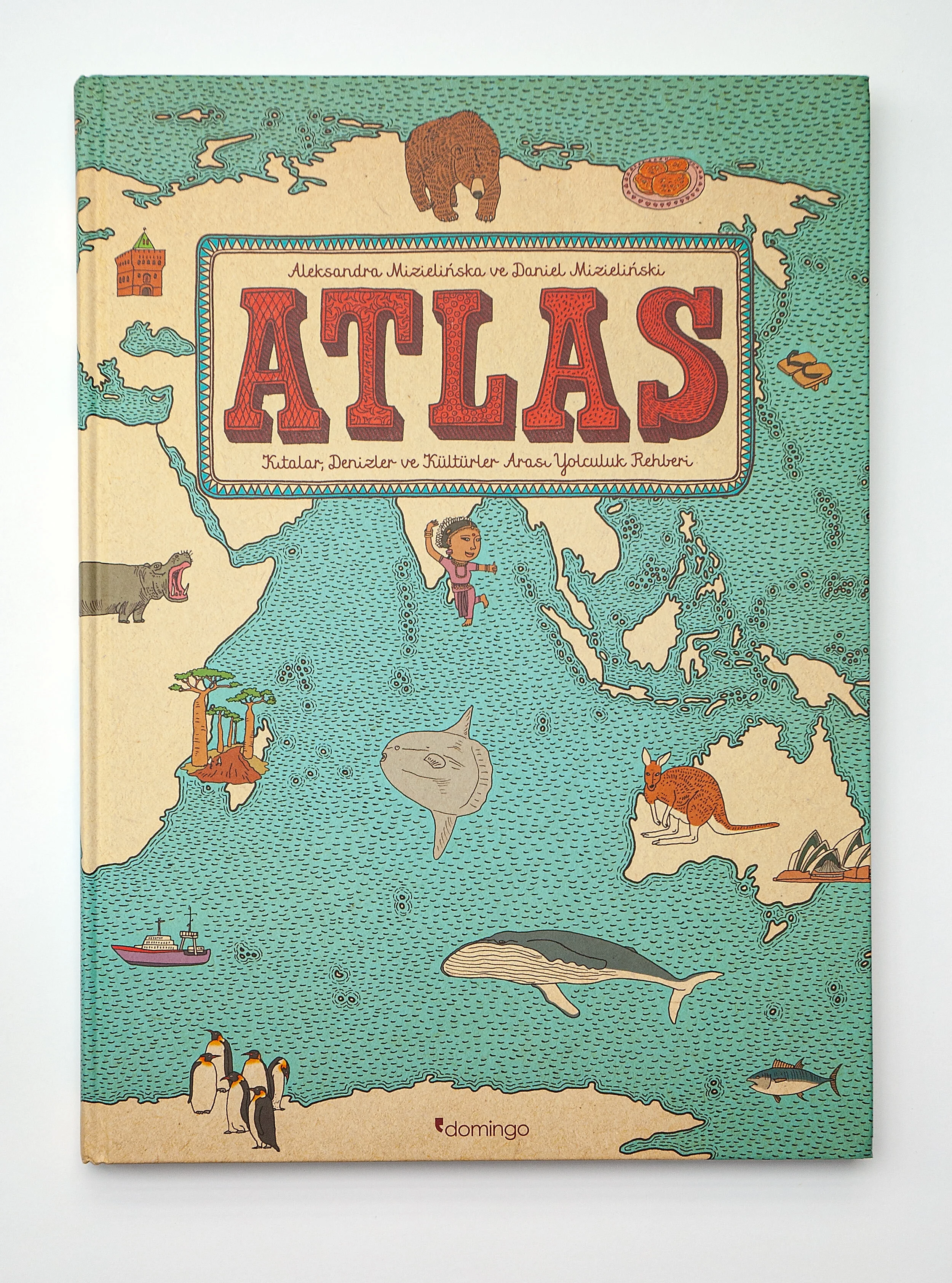
Turkish, Atlas, Domingo, 2019, ISBN: 978-605-4729-73-9
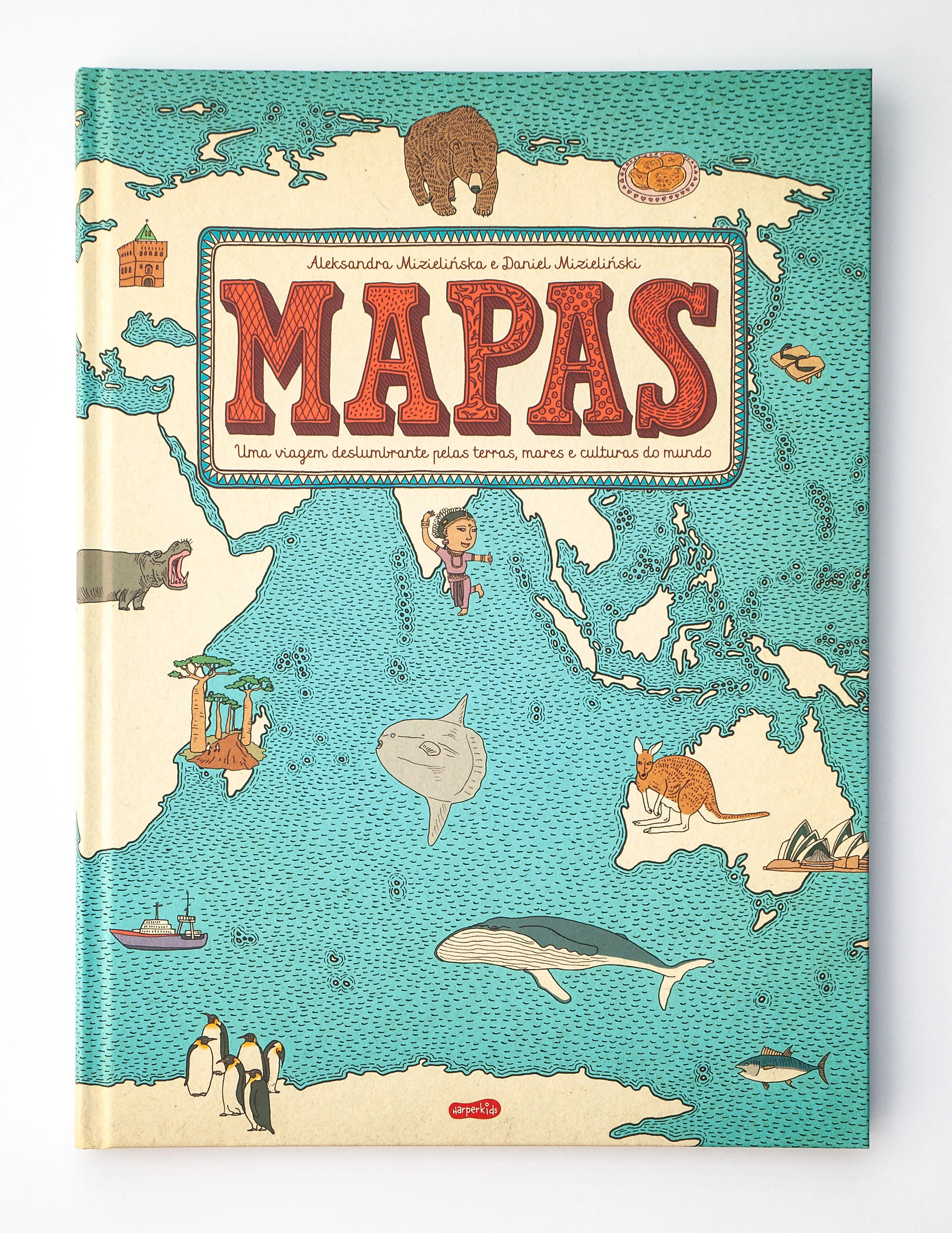
Portuguese, Mapas, Harperkids, Harper Collins Ibérica, 2019, ISBN: 978-84-17222-53-6
Afrikaans, Kaarte, Protea, 2019, ISBN: 978-1-4853-0892-8
English (RPA), Maps, Protea, 2019, ISBN: 978-1-4853-0893-5
Catalan, Atles del Món, Maeva Young, 2018, ISBN: 978-84-17108-31-1
Slovenian, Zemljevidi, Mladinska Knjiga, 2018, ISBN: 978-961-01-5003-9
Estonian, Kaardid, Kirjastus Varrak, 2017, ISBN: 978-9985-3-4067-7
Georgian, რუკები, Diogene, 2017, ISBN: 978-9941-11-559-2
Latvian, Atlants, Karšu izdevniecība Jāņa sēta, 2017, ISBN: 978-9984-07-731-4
Portuguese (BR), Mapas, wmf martinsfontes, 2017, ISBN: 978-85-469-0143-2
Czech, Mapy, Host, 2016, ISBN: 978-80-7491-708-0
Romanian, Hărţi, Humanitas, 2016, ISBN: 978-973-50-5134-1
Slovak, Mapy, Slovart, 2016, ISBN: 978-80-556-2475-4
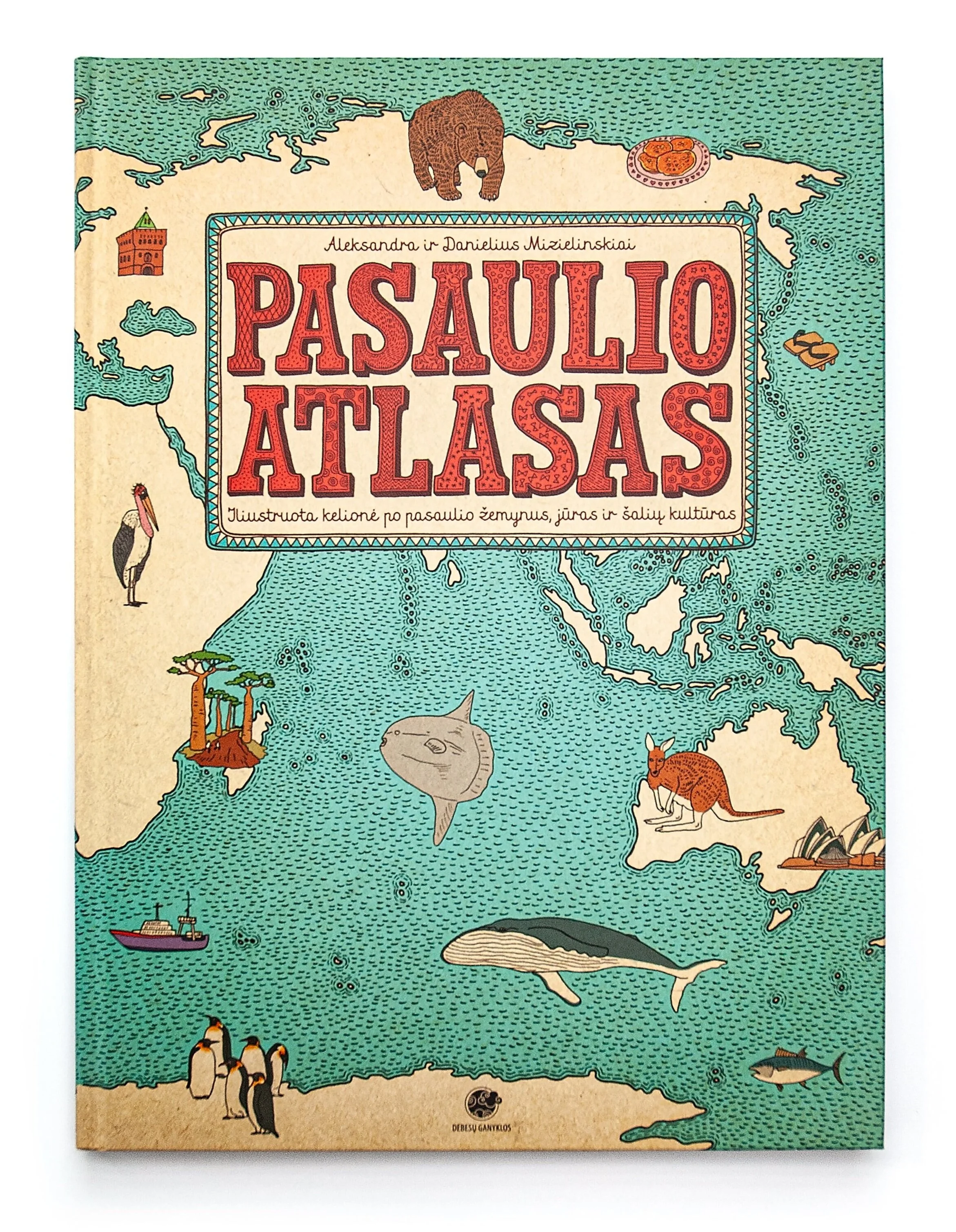
Lithuanian, Pasaulio atlasas, Debesų ganyklos, 2016, ISBN: 978-609-473-007-8
Chinese Traditional, 地圖, Global Kids Books, 2015, ISBN: 978-986-320-654-5
Icelandic, Kort, Vaka-Helgafell, 2015, ISBN: 978-9979-2-2313-9
Korean, 지구촌 문화 여행, Greenbooks, 2015, ISBN: 978-89-5588-255-1
Spanish, Atlas del Mundo, Maeva young (Ediciones Maeva, S.A.), 2015, ISBN: 978-84-16363-46-9
Thai, แผนที่ภูมิศาสตร์และวัฒนธรรม, Nanmeebooks, 2015, ISBN: 978-616-04-2768-0
Japanese, マップス 新・世界図絵, Tokuma Shoten Publishing Co., 2014, ISBN: 978-4-19-863785-9
Danish, Kort over verden, Forlaget Carlsen, 2014, ISBN: 978-87-11-326275
Finnish, Suuri karttakirja, Nemo, 2014, ISBN: 978-952-240-263-9
Hungarian, Világlátó, Manó Könyvek, 2014, ISBN: 978-963-403-106-2
Norwegian, Kart, Fontini, 2014, ISBN: 978-82-93346-01-2
Swedish, Kartor, Alfabeta, 2014, ISBN: 978-91-501-1667-0
Ukrainian, Карти, Старого Лева, 2014, ISBN: 978-617-679-063-1
Chinese Simplified, 地图, Beijing Yuanliu Classic Culture Ltd, 2014, ISBN: 978-7-221-11534-8
Dutch, Atlas, Lannoo, 2013, ISBN: 978-94-014-09328-5
English (GB), Maps, Big Picture Press (Templar Company Limited), 2013, ISBN: 978-1-84877-301-1
English (US), Maps, Big Picture Press (Candelwick Press), 2013, ISBN: 978-0-7636-6896-9
Russian, Карты, Самокат, 2013, ISBN: 978-5-91759-202-2
French, Cartes, Rue du Monde, 2012, ISBN: 978-2-35504-236-2
German, Alle Welt, Moritz Verlag, 2012, ISBN: 978-3-89565-270-7
Italian, Mappe, Electa Kids, 2012, ISBN: 978-88-370-9274-0
You can find a Google Sheet with a list of all our foreign editions here.


FAQ
If you're still reading this then wow! – I can barely make it here myself. Maybe this final section will satisfy your curiosity. Those really are questions we had to answer many many MANY times.
1. Do you like travelling? What are your favourite places to go to?
Yes, we like travelling. Our favourite way to spend holidays is moving from place to place rather than sitting in one location.
2. How did it occur to you to create a map book together?
We discuss many ideas for different books we’d like to make. We choose a topic that is enough interesting for us to be able to work with it for a few upcoming years. Maps in general are very inspirational and powerful concept. That’s why so many people love them. You can use them to tell a lot of stories and there is something absolutely compelling in the way maps can describe and simplify the world around us.
3. What were your criteria for selecting the countries? How did you decide which countries to include in your book? Were there any personal preferences?
We started with map of Poland. Then we made USA and Japan, because we find them especially interesting. After that we did Nepal because of all the legendary Himalayan stories and famous adventurers thanks to whom we could learn about unique culture of this region.
We obviously chose many European states. They are culturally and geographically close to us and we are connected with them in many ways. Nevertheless we tried to keep a healthy balance with countries from other continents.
It’s hard to avoid personal preference since we’re the only authors of the book. We’re aware that “Mapy” is very Europe-centered but that’s because this is the part of the world that is closest to us. It’s impossible to make an objective book about the world. That wasn’t our goal but we keep on adding new maps, so maybe one day this book won’t be a selection of countries but a complete set.
4. What did you enjoy most when working on your map book?
We’ve enjoyed learning new stuff. There are many interesting facts in the book that we didn’t know before.
5. For you personally, what were the most interesting and most surprising discoveries when you were doing your researches?
We don’t remember one thing in particular but the whole research was full of surprises.
6. Did you expect the book to be such a big success?
No. We never expected such a big success but we’re extremely happy to be able to reach such wide and diverse audience.
7. What was the most difficult thing during working on the book?
Finding things that can represent every country best. It was hard to visually describe territories that are remote and exotic for us. It was important that people who live in all included states could identify with their homeland’s depiction.
8. How do you work together?
We both write and draw and we work together on every book.
9. How did you meet?
We’ve met at the Academy of Fine Arts in Warsaw. We were studying on the same year on the Faculty of Graphic Art. Since then we have been working and living together.